Arto's Blog
| « Road through the wilderness | Seaside villages, huge leaves and roadworks on the Carretera Austral » |
Like a painted scenery
Posted: 2015-02-21 14:52:00, Categories: Travel, Cycling, Hiking, Chile, 1462 words (permalink)
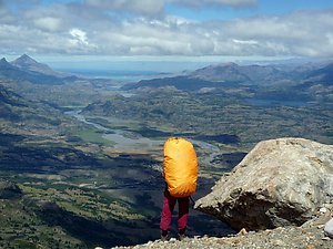 We cycle with backpacks on top of our panniers so we can stop, repack,
leave the bicycles and proceed on foot whenever we want. In National
Reserve Cerro Castillo we went hiking for half a week, mostly through
valleys but also over two mountain passes, near sharp high peaks and
glaciers. On the top of the second pass, we had a view towards the
south over hills, valleys, rivers, lakes and forests, looking like a
painting.
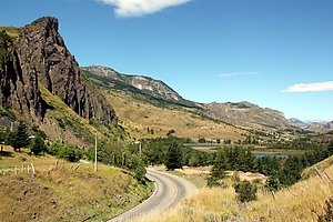 After a couple of days in Coyhaique we continued further towards south
on the Carretera Austral. On the first day we rode through a rather
dry landscape with a strong tailwind pushing us forwards. In the best
downhill I reached 76 km/h and Sandra 66 km/h. Late afternoon just
before the village of El Blanco we stopped at a house which had
chicken running around in the garden and a sign "Eggs for
sale". We asked for six, the friendly old man packed us seven and
didn't even want to accept any payment. On the opposite side of the
road was a house selling home made cheese and we also went there to
buy some. This time we paid but got a quiet wind protected place
to camp behind the house for free.
 On the following day we continued towards National Reserve Cerro
Castillo and soon crossed the border of the park. The road was a
steady uphill, but paved and not too steep. A French couple in
Coyhaique had given us a hiking map of the area which they didn't
need. Around 2 pm we arrived at the starting point of one of the two
longer trails crossing the park. We checked that we had enough food
and made a rather spontaneous decision to go on the trail. We hid our
bikes and panniers between bushes, packed everything we needed in two
backpacks and started walking.
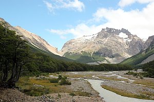 The first 15 km of the trail was relatively flat, following a river
valley through a forest. It was fairly easy walking except for several
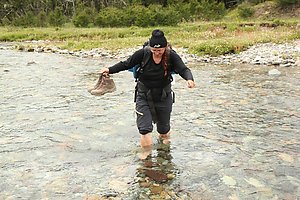
small river crossings without bridges, which meant that we had to take
off our shoes and walk through the cold water. Sandals would have been
useful but we had left ours at the bikes to save weight. On the first
evening we walked about two thirds of the flat part and set up our
tent next to the river. Officially wild camping is not allowed in
Chilean national parks and reserves, but in less frequented areas it
is usually rather easy. We're not doing open fires and naturally not
leaving any trash behind us.
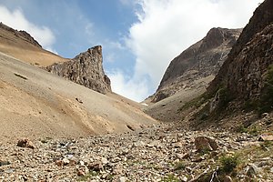 During the night and morning it was raining, but shortly before noon
the rain stopped and there were more and more openings in the clouds.
We came to the park rangers' hut and got some information about the
route ahead of us. In Chile it's even more useful to talk to the
rangers than in Europe because the maps are usually not very detailed
and often outdated. Also in this case a couple of new campsites and
one trail weren't marked on the map, and another trail which was on it
didn't exist any more.
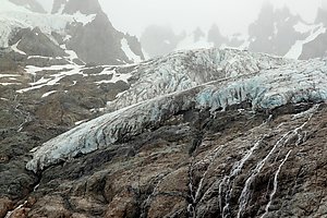 After a few more kilometers through the forest next to the river the
path started climbing up towards a pass. It wasn't a very long climb,
about 500 meters of ascent on a good trail brought us to 1300 meters
of altitude. That doesn't sound very high, but it was comparable to trails a thousand meters higher in the Alps: above the treeline, windy and snow fields remaining
in places where the sun didn't shine the whole day long. A nearby
glacier reaching down to about 1500 meters of altitude was keeping the
temperature lower than it otherwise would have been. We could see the
glacier from just a couple of hundred meters away, with melting water flowing
down in numerous small streams, joining each other further down to
form a river.
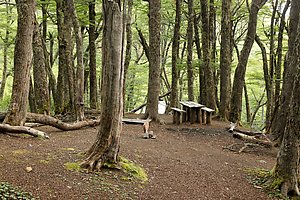 The crossing of the pass was easy, the descent on the other side rocky
and steep. It probably took us more time to go down than we had needed
to hike up. However, after an hour of carefully descending step by
step we had the steep part behind us and the trail became easier
again. It went still down for quite a while first through gravel and then through forest
before reaching the campsite. The facilities were very basic as on
every site in Cerro Castillo: some flat space to set up tents, a dry
toilet, a table and a couple of wooden benches, drinking water from
the river flowing by. We had the whole site for us, the park rangers
at the hut had been the only people we met during the whole day.
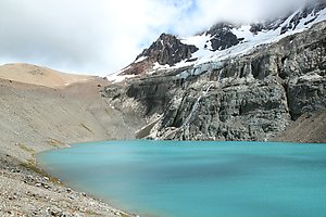 During the night and morning it was raining again but similarly to
previous day the rain stopped before noon, with a mix of sunshine,
clouds and a couple of short showers during the rest of the day. The
trail led us up to a clear mountain lake with a small meadow of green
grass on the eastern shore, gravel and rocks in all other directions.
We had a picnic by the lake and then climbed the steep and rocky slope
up to a ridge and a small highland plateau. There we met the first
other hikers since the start of our walk. It was the most famous
section of the park and there was also a shorter trail leading to the
same point, starting directly from the town of Villa Cerro Castillo.
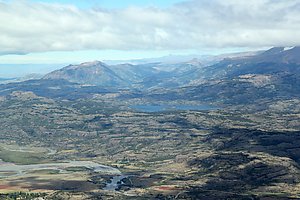 On top of the ridge we could see down to the town and over the whole
landscape towards the south. The valley of river Ibanez dominated the
foreground, behind it were hills, lakes, other rivers, patches of
forest and higher mountains in the background. The Carretera Austral
road crossed through from north to south-west with a couple of tiny
side roads starting from it. With the shadows of clouds over the land
the scenery looked almost like a painting. We sat down and watched it for a
while before continuing further on the trail.
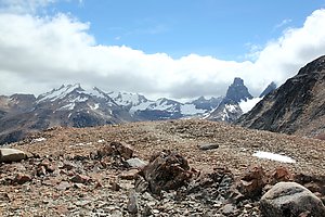 The trail went up on a shoulder of a mountain at about 1600 km of
altitude, the highest point of the hike. On our right we could see the
sharp peaks of the Cerro Castillo, partly hidden behind clouds. The
wind was blowing hard and we had to watch our steps when coming down
along the steep rocky slope on the other side. Then the trail went
again inside the forest where it was easier to walk, but still quite a
way until the campsite. Distance marked on the map was 1,4 km, which
was apparently just the straight line between the two coordinates and
had nothing to do with the actual walking distance on the path. On the
way, we met Simon, Jose and Clara, three Chileans from Santiago, and
walked together with them the last kilometers. Then it was time to set
up the tent, cook dinner and go to sleep as usual.
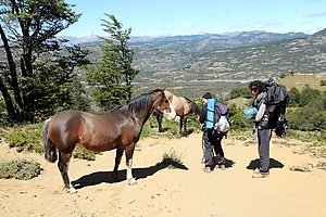 At the campsite there were a few more hikers going to different
directions. We headed down towards Villa Cerro Castillo, again
together with Simon, Jose and Clara. On the way we had a 1,5 hour
break when Simon set up his equipment and made a multi-channel
sound recording for his sound landscapes project. It was a sunny, hot
day and we were all quite tired when finally arriving to the town.
Next to the main road was a funny looking hamburger restaurant built
into two old buses. We ordered a burger each and a plate of french
fries to share. The service was slow but the burgers good and huge
— I was satisfied with one and Sandra with a half, the rest we
packed with us to eat later in the evening.
 After eating we bought fresh fruits and other food at the
minimarket on the opposite side of the street, said good bye to the
Chileans and started hitchhiking back to our bikes. There were no
buses any more, only a few cars and some competition from other
hitchhikers so we had to wait for some time. Finally we managed to
convince a pickup driver that there was enough space for us at the back
and got a ride. It was a cool ride through mountain landscape in the
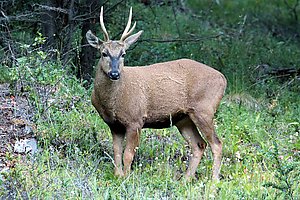
evening light. And we were specially lucky because two huemules (a
Chilean species of deer) were next to the road and the family in the pickup was
also enthusiastic to see them. They stopped and we got good photos.
Back at the starting point of the trail our bikes were where we had left them behind a bush. We camped for a night, repacked our gear for cycling and continued further south along the Carretera Austral.
1 comment

Copyright Arto Teräs <ajt@iki.fi>, licensed under the Creative Commons Attribution-Share Alike 3.0 Unported License. (Unless otherwise mentioned in individual photos or other content.)