![]()
Arto's Blog
Winter nights in the Alps
Posted: 2011-03-24 21:52:14, Categories: Travel, Austria, Hiking, 493 words (permalink)
 Most of the mountain huts in the Alps close their doors and send their
staff home for the winter, approximately from mid October until mid
April. However, many have a winter room which is either unlocked
or accessible using an alpine club key. The winter rooms are wonderful
places to cook a simple but enjoyable dinner, to look at the stars, to sleep
and to wake up to the morning sun with spectacular views.
Most of the mountain huts in the Alps close their doors and send their
staff home for the winter, approximately from mid October until mid
April. However, many have a winter room which is either unlocked
or accessible using an alpine club key. The winter rooms are wonderful
places to cook a simple but enjoyable dinner, to look at the stars, to sleep
and to wake up to the morning sun with spectacular views.
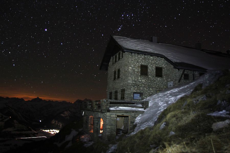
This winter we visited three different huts, for four nights in total. Twice there were nobody else, once we shared the room with a group of three others, and once on a weekend with particularly good weather there were about 20 hikers and the warden staying in the same hut. However, in that case the whole hut was open so there was enough space for everybody.
The photo of this blog entry is of Bad Kissinger Hütte, which is located in the Tannheimer valley, Austria, about 80 km south of our home in Memmingen. That's one of the easiest huts to reach with about 700 meters of altitude to climb along an easy path. It's also located on the south slope, which means less deep snow, particularly when the winter is already turning towards spring. For us it took around 2,5 hours to climb up including a couple of short breaks, and we did not have snowshoes or skis.
In contrast to the summer when the huts have full restaurant facilities, the winter rooms operate on a self service basis. Mattresses and blankets are usually provided so one could go just with a thin travel bedsheet, but we always carry our sleeping bags to be sure of staying warm. We've also taken a camping cooker which generally has been unnecessary: all the winter rooms we've been to this far had a cooking possibility with either wood or gas. In Bad Kissinger Hütte we did use our own kettle though, as there were two pans but no pots. Nowadays the winter rooms also commonly have an electric light powered by a battery, which is recharged by a solar panel during the day.
The cost of an overnight stay is usually 5-10 euros for alpine club members and 10-20 euros for non-members, depending on the place. Payment works on a basis of trust: people are expected to write their names in the visitor book and make a bank transfer afterwards to the account of the organization which takes care of the hut.
One piece of equipment which we found out to be a nice addition on the winter hikes is a snow glider, a piece of plastic just big enough to sit on, with a handle in the front. When coming back, we can often have fun by gliding down on the snow instead of walking during part of the way. The gliders are lightweight to carry so even if the slope is too icy, bumpy or otherwise unsuitable for using them, it doesn't matter very much.
On the München-Venedig trail, part 3: Italian flatlands
Posted: 2010-09-27 17:41:01, Categories: Travel, Hospitality exchange, Italy, Hiking, 818 words (permalink)
 We
descended from the Alps to Longarone, a small town near Belluno, in
North-Eastern Italy. The high peaks of the Dolomites gave way to
lower, grass-covered mountains, then hills, and finally to the
flatlands of the Veneto region. The route followed small roads and
tractor tracks through vineyeards, corn fields, fruit gardens and
small villages. On the way, we had a few wonderful stays with
CouchSurfing hosts.
We
descended from the Alps to Longarone, a small town near Belluno, in
North-Eastern Italy. The high peaks of the Dolomites gave way to
lower, grass-covered mountains, then hills, and finally to the
flatlands of the Veneto region. The route followed small roads and
tractor tracks through vineyeards, corn fields, fruit gardens and
small villages. On the way, we had a few wonderful stays with
CouchSurfing hosts.
In Longarone we were welcomed by Gigi, Francesca and their family, who had heard about CouchSurfing from an Italian TV program. We were their first guests. They were first a bit puzzled what they could show us as mountains were the most popular attraction in the area and we had just been hiking for almost three weeks. However, we didn't need much sightseeing — a tour in the garden, chatting, relaxing and family dinners including their own vegetables, local cheese and wine were just perfect. We also got good hints which route to take during the following two days.
From Longarone we climbed once more up to 1700 meters and descended to Tarzo. There we stayed two nights with Helio and Lori, a warm and funny Brazilian-Italian couple. With them and their friends we had a tour in nearby Vittorio Veneto old town, followed by more than excellent ice cream in a local gelateria and the most entertaining wine tasting ever hosted by Lori's father, also called Gigi. Helio and Lori didn't speak much English but it didn't stop us communicating in a mix of about five different languages, while enjoying delicious Brazilian food and the friendly atmosphere in their home.
One full day walk later in Spresiano we met Francesco, a guy of about same age than us who had recently come back from a 6 month tour around the world. We all had one thing in common: quitting our jobs to travel at least once in our lives. So it was no wonder we had a lot to talk about. :) Francesco had a lot of ideas about how to change his life and be happy. We might meet him again one day in his small cocktail bar on a quiet beach, where he will mix a drink for us.
After Spresiano we didn't have any more CS hosts and were relying on hotels and guesthouses instead. We also considered sleeping outside, but without a tent or a mosquito net it would have been a bit tricky. In a few places the personnel immediately guessed which trail we were on, probably thinking "Again two of those crazy Germans walking to Venice".
On the flat parts we could have taken exactly the same route by bicycle so it was a good opportunity to compare these two ways of travel. By walking we saw a few more details in the gardens of the houses and it was a bit easier to talk to each other. On the other hand we were limited to about 25 km per day while by bicycle we could have easily covered three times that, without missing much in the scenery or opportunities to communicate with locals. So we sometimes felt a bit silly walking along the roads, but nevertheless decided to go on for the couple of remaining days.
After a total of 26 days of walking (including two rest days) we arrived in Lido di Jesolo, a beach resort located about 20 km from Venice. It was a big contrast to all the other places we had been to on the trip. There were hundreds of hotels and restaurants on a few kilometers of shoreline, and of course thousands of tourists on a beach holiday. On the beach there were sections of sunshades and chairs reserved to each hotel, but fortunately the waterline was freely accessible for all. We walked to the waterfront and took photos in our hiking outfit in front of the surprised beach-goers.
From Lido di Jesolo it was only a one day walk to Punta Sabbione and a half an hour water bus ride to Venice, our final destination. We spent a couple of days exploring the alleys and canals, photographing the colourful houses of Burano and relaxing on the beach before returning home. There was a good feeling about completing the tour, but it was of course not as important than the experiences during the trip.
Overall, walking for four weeks was an interesting experience. The first two and half weeks on the Alps (see parts one and two) were beautiful and the mountains started to feel like home in way I had never felt on shorter hikes. I would do it again, although perhaps carrying a tent and choosing my own route instead of following a book. On the other hand, I don't think it'll be my ambition to walk hundreds of kilometers along roads as some people do. On roads I prefer the bicycle or some other kind of vehicle, depending on the trip.
On the München-Venedig trail, part 2: The Dolomites
Posted: 2010-09-27 17:40:34, Categories: Travel, Italy, Hiking, 636 words (permalink)
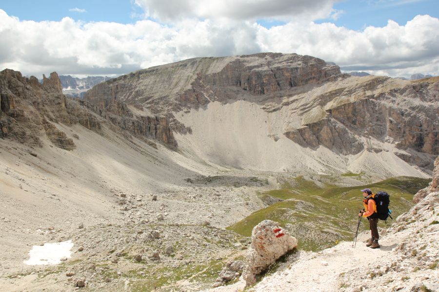 The
Dolomites looked quite different from the German and Austrian
Alps. The rocks had sharper shapes, slopes were steeper and overall
there was much less vegetation. Different layers of stone and rock
often had their own colors — "European Arizona" as
Sandra called it.
The
Dolomites looked quite different from the German and Austrian
Alps. The rocks had sharper shapes, slopes were steeper and overall
there was much less vegetation. Different layers of stone and rock
often had their own colors — "European Arizona" as
Sandra called it.
We still had a couple of cloudy and rainy days, but were mostly enjoying quite sunny weather, especially in the mornings. Our daily schedule gradually shifted to earlier hours. It became easier to get up in the mornings, and we were not any more the last ones to leave from the huts. During the first week it had always been Sandra waking me up, but it changed so that I was just as often the one who was getting up first — which was a surprise for both of us.
I also got better into the flow in walking. We descended to a valley and climbed up, over highlands, sometimes over a mountain passes and then down to a valley again. The days merged to each other so that it was hard to remember which date or day of the week it was. There was a feeling of traveling as scenery changed slowly but surely. We didn't go very far on any single day, but the events and views of the first days of the trip were already far behind.
Huts were more full than they had been during the beginning of the trip. We couldn't count on having a bed without making a reservation beforehand — something which we both dislike. Of course the huts would usually find some emergency space outside the normal sleeping areas instead of leaving hikers out in the cold, but it would have been extra hassle both for us and them. We took the habit of calling 1-3 days in advance, and canceling the reservations as early as possible when we changed our plans.
Already on our second day of the trip we had met other hikers who were also on the way to Venice. Some of them were faster than us and some slower, but about half a dozen were traveling more or less the same speed. We didn't walk in a group and occasionally would also make different choices of which hut to stay in, but then suddenly meet again a day or two later. As time passed a kind of companionship developed. During the day we were often guessing where our friends would be, and looking forward to seeing them again, sitting together at the dinner table and comparing experiences.
Our last day in the Dolomites was perhaps the most memorable. We stayed in Rifugio Pramperet and set our record by being on the trail at 6:46, a whole hour earlier than any of the mornings before — and without using alarm clock. The morning sun was casting a beautiful light on the mountains as we were climbing uphill. Up on the ridge there were a group of chamois, a kind of goat-antilopes. They ran away well before we reached them, but we were close enough to see well how elegantly they walked up and down on the steep slopes.
We reached the peak of Cime di Citta Sud (2450 m) at around 8:30 am. It wasn't the highest mountain in the area, but the view was gorgeous in all directions. It was also one of the only times we actually climbed on a peak. We cooked a second breakfast near the top before starting our long descent along Val del Ross. The open grasslands changed to forest, the trail followed a river, then there was a road, a few houses, then a small village. Late in the afternoon we reached the town of Longarone, bought two large ice creams and a big bag of fresh fruit, and called our CouchSurfing hosts. That's the beginning of part 3.
On the München-Venedig trail, part 1: The Austrian Alps
Posted: 2010-09-27 17:39:21, Categories: Travel, Austria, Italy, Hiking, 621 words (permalink)
 One of
Sandra's dreams was to go for a long walk one day. Like her, I had
been on many short hiking trips, lasting up to one week, but never
longer than that. So we decided to spend four weeks of our summer
holiday by walking over the Alps.
One of
Sandra's dreams was to go for a long walk one day. Like her, I had
been on many short hiking trips, lasting up to one week, but never
longer than that. So we decided to spend four weeks of our summer
holiday by walking over the Alps.
Our route was mostly following the München-Venedig trail, a 550 km hiking route from Munich, Germany to Venice, Italy. Apparently a few hundred people walk at least a part of the trail every year. The route is described with minor differences in at least three books, all in German. We were carrying two of them with us.
We skipped the first 150 km and started near Innsbruck in Austria. The first day was easy: a bus to Tulfes and a ski lift up to 2000 meters left only a few kilometers of distance and 600 meters of altitude to climb up to Glungezer hut, our first place to stay. This time we didn't carry a tent, but our backpacks were loaded with a camping cooker, food, clothes and other equipment needed for the trip.
Second day showed us the reality of the mountains: sunshine had turned into snow and clouds with almost zero visibility. We chose a route which stayed most of the time on a ridge above 2500 m, trusting the forecast which suggested weather to clear up by noon. Well, it didn't and we spent a full day doing our best to find safe steps on the slippery rocks. It was almost dark when we arrived at the next hut.
On the following day the weather was better again and we got used to the already familiar Alpine scenery: snow-capped peaks, rocky ridges, mountain lakes and grass-covered highlands where cows and sheep were grazing between the mountain flowers. A new companion we hadn't so often seen before were marmots, who were squeaking and standing on two feet besides their holes, looking at us.
The trail never climbed over 3000 meters but rarely descended below 1500 meters. The weather varied rapidly from 25°C sunshine to cold rain, with temperature occasionally falling down to 0°C and rain turning into sleet. Once we had to change our planned route: Friesenbergscharte was not passable due to too much snow and clouds. We hiked about 10 km west and crossed the ridge at Alpeinerscharte, knee deep in the fresh snow. On the way we stayed one night at Geraerhütte, which turned out to be one of the most charming huts of the whole trip.
I had usually traveled with a tent so hiking from hut to hut was something new for me. Huts in the Alps are quite well equipped, even luxurious: most have nowadays electricity, hot showers, water closets and a fully equipped restaurant. Perhaps a bit surprisingly, they are still considerably cheaper than hotels and guesthouses in the valleys, at least for Alpine club members. A bed in the dormitory costs 8-10 euros for members (about double from non-members) and meal prices are similar to simple restaurants down in the valleys.
Where the huts differ between each other is the atmosphere. Some are friendly and cozy family businesses where the hosts have time to talk with every guest personally, while others are more busy hostel and restaurant establishments. Small huts far away from roads and cable cars are usually the best. Our favourites on this hike were Geraerhütte (Austria), Kreuzwiesen Alm (Italy) and Rifugio Pisciadu (Italy).
Actually we were in Austria only the first five days before arriving in Italy. However, the main local language was German still for a week and both the mountains and architecture of houses remained similar to Austria. It took a few more days to reach the Dolomites, which looked quite different. More about them in part 2.
Hetta-Pallas-Ylläs trail: Peaceful felltops and mosquito-filled valleys
Posted: 2010-07-25 02:32:08, Categories: Travel, Finland, Hiking, 948 words (permalink) 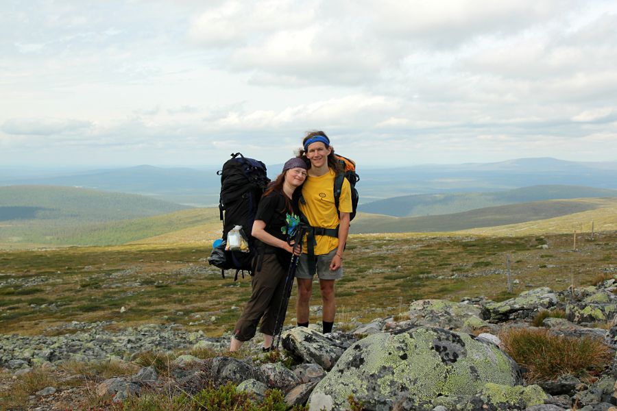 During the first week of July Sandra and I did a one week hike in the Pallas-Yllästunturi national park. We enjoyed peaceful, broad views while walking on the higher fells and beautiful mysterious looking trees on the lower peaks. Valleys in between were lush and full of flowers, but well defended by the Finnish air force: clouds of mosquitoes.
The Hetta-Pallas trail is the oldest marked hiking trail in Finland and therefore easy to access by public transport. A night train from Helsinki carried us to Rovaniemi, from where we continued by bus to Hetta. A local shopkeeper was already waiting to take us over the Ounasjärvi lake to the point where the trail started.
On the first evening we had a short walk through forest to the Pyhäkero wilderness hut. To our surprise there was nobody else so we had the whole place for just the two of us. We cooked rice and vegetables for dinner and watched how the late evening sun was casting a warm orange glow on the buildings and trees. Then we laid out our sleeping bags and were looking forwards to a quiet night after a long day of traveling.
Bzzzt. Whack. Bzzzzzzt. There weren't a large number of mosquitoes around but enough to make it difficult to sleep. We were not sure if they were coming through the chimney, narrow holes around the door or somewhere else. Nevertheless, every time we thought we'd got rid of them a few more appeared. A lesson learned for the following nights: cook in the huts but set up the tent outside to have a good rest. An alternative would be to carry a mosquito net and use it inside the huts.
After Pyhäkero the trail climbed above the treeline and a light wind kept most of the insects away. It was cloudy but we saw dozens of kilometers in every direction over the fells, forests and lakes in the mostly uninhabited land. The most common sound was "beep", which a bird called kapustarinta (in Finnish) was singing while sharing the trail with us.
Hannukero is almost exactly half way on the 55 km trail from Hetta to Pallas and therefore the most popular place to stop. It was almost like a small village with several buildings, including both a free and reservation hut (pay in advance to get a key) with two rooms each, toilets, wood storage, fire places and even a sauna. The place looked like being designed for a hundred hikers but this time there were less than ten. The sauna was great, first time for both of us to enjoy a sauna in the middle of a hike. We stayed awake long enough to see the midnight sun before going to sleep — this time in our tent.
In early morning we first thought it was raining. That seemed odd because the sun was shining at the same time. A quick look outside solved the puzzle: the sound wasn't coming from the rain drops but instead hundreds of mosquitoes flying back and forth between the inner and outer tent. However, they didn't get inside so we quickly got used to the sound and it didn't bother us any more.
The section between Hannukuru and Pallas nature center went over the highest fells of the region, rising to about 800 m of altitude. The scenery showed its best when approaching Taivaskero, the highest point. The peak itself was too large and flat to have a great view towards any direction.
The popular part of the trail ended at the Pallas hotel and nature center. Popular in this case meant that we saw perhaps 50 people in total during three days. Summer was clearly not high season: most visitors come either in early autumn, or in late March or April which are the best months for cross country skiing.
We continued hiking still further towards Ylläs which is at the southern end of the park. The trail became smaller, more forested and less traveled: we met only two other hikers in three days. There were less open views but many interesting small details: gorgeous old spruces and twisted birches, wild orchids and cute, cozy wilderness huts waiting for the occasional wanderer. Our favourite was the "porokämppä" Mustavaara hut, which also reindeer herders are still using. Quite many birches were broken at a height of 1-1.5 meters and it seemed to have happened fairly recently. We were wondering if it was due to unusual snow conditions last winter or some other weather phenomena.
The air force became stronger during the Pallas-Ylläs part of the trail. Sun brought horseflies out and shades were well populated with mosquitoes. A cap with mosquito net, clothes and a bit of repellent kept most of them away but always a few found their way through. I didn't mind too much but it was difficult for Sandra whose skin was reacting more strongly on the bites than mine. In a way we were lucky of not having any midges, tiny flies whose bites are more painful than regular mosquito stings. However, the sheer number of mosquitoes made it impossible to sit outdoors and enjoy relaxing breaks except in places with enough wind.
We decided to end our hike at Äkässaivo lake about 15 km north of Ylläs. My aunt Pirkko came to pick us up and we enjoyed sauna at her home in Kolari, 40 km further south. It was actually already second time this year we visited her: we had been also cross country skiing in the Ylläs area just before Easter. After one and a half days and several delicious meals cooked by her we took a train back south to sunny, hot Helsinki.

Copyright Arto Teräs <ajt@iki.fi>, licensed under the Creative Commons Attribution-Share Alike 3.0 Unported License. (Unless otherwise mentioned in individual photos or other content.)