Arto's Blog
Pages: << 1 2 3 ...4 ...5 6 7 ...8 ...9 10 11 12 ... 31 >>
Like a painted scenery
Posted: 2015-02-21 14:52:00, Categories: Travel, Cycling, Hiking, Chile, 1462 words (permalink)
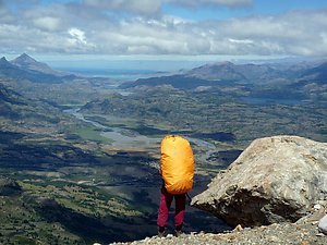 We cycle with backpacks on top of our panniers so we can stop, repack,
leave the bicycles and proceed on foot whenever we want. In National
Reserve Cerro Castillo we went hiking for half a week, mostly through
valleys but also over two mountain passes, near sharp high peaks and
glaciers. On the top of the second pass, we had a view towards the
south over hills, valleys, rivers, lakes and forests, looking like a
painting.
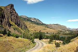 After a couple of days in Coyhaique we continued further towards south
on the Carretera Austral. On the first day we rode through a rather
dry landscape with a strong tailwind pushing us forwards. In the best
downhill I reached 76 km/h and Sandra 66 km/h. Late afternoon just
before the village of El Blanco we stopped at a house which had
chicken running around in the garden and a sign "Eggs for
sale". We asked for six, the friendly old man packed us seven and
didn't even want to accept any payment. On the opposite side of the
road was a house selling home made cheese and we also went there to
buy some. This time we paid but got a quiet wind protected place
to camp behind the house for free.
 On the following day we continued towards National Reserve Cerro
Castillo and soon crossed the border of the park. The road was a
steady uphill, but paved and not too steep. A French couple in
Coyhaique had given us a hiking map of the area which they didn't
need. Around 2 pm we arrived at the starting point of one of the two
longer trails crossing the park. We checked that we had enough food
and made a rather spontaneous decision to go on the trail. We hid our
bikes and panniers between bushes, packed everything we needed in two
backpacks and started walking.
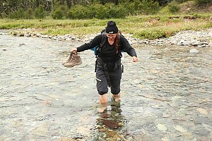
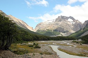 The first 15 km of the trail was relatively flat, following a river
valley through a forest. It was fairly easy walking except for several
small river crossings without bridges, which meant that we had to take
off our shoes and walk through the cold water. Sandals would have been
useful but we had left ours at the bikes to save weight. On the first
evening we walked about two thirds of the flat part and set up our
tent next to the river. Officially wild camping is not allowed in
Chilean national parks and reserves, but in less frequented areas it
is usually rather easy. We're not doing open fires and naturally not
leaving any trash behind us.
 During the night and morning it was raining, but shortly before noon
the rain stopped and there were more and more openings in the clouds.
We came to the park rangers' hut and got some information about the
route ahead of us. In Chile it's even more useful to talk to the
rangers than in Europe because the maps are usually not very detailed
and often outdated. Also in this case a couple of new campsites and
one trail weren't marked on the map, and another trail which was on it
didn't exist any more.
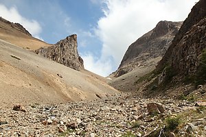
 After a few more kilometers through the forest next to the river the
path started climbing up towards a pass. It wasn't a very long climb,
about 500 meters of ascent on a good trail brought us to 1300 meters
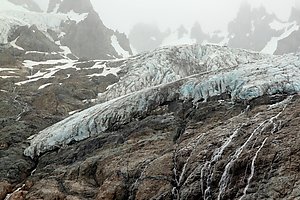
of altitude. That doesn't sound very high, but it was comparable to trails a thousand meters higher in the Alps: above the treeline, windy and snow fields remaining
in places where the sun didn't shine the whole day long. A nearby
glacier reaching down to about 1500 meters of altitude was keeping the
temperature lower than it otherwise would have been. We could see the
glacier from just a couple of hundred meters away, with melting water flowing
down in numerous small streams, joining each other further down to
form a river.
 The crossing of the pass was easy, the descent on the other side rocky
and steep. It probably took us more time to go down than we had needed
to hike up. However, after an hour of carefully descending step by
step we had the steep part behind us and the trail became easier
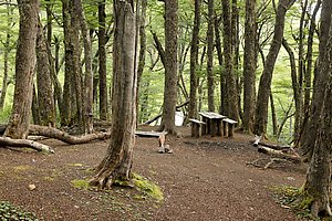
again. It went still down for quite a while first through gravel and then through forest
before reaching the campsite. The facilities were very basic as on
every site in Cerro Castillo: some flat space to set up tents, a dry
toilet, a table and a couple of wooden benches, drinking water from
the river flowing by. We had the whole site for us, the park rangers
at the hut had been the only people we met during the whole day.
 During the night and morning it was raining again but similarly to
previous day the rain stopped before noon, with a mix of sunshine,
clouds and a couple of short showers during the rest of the day. The
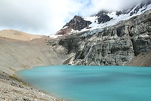
trail led us up to a clear mountain lake with a small meadow of green
grass on the eastern shore, gravel and rocks in all other directions.
We had a picnic by the lake and then climbed the steep and rocky slope
up to a ridge and a small highland plateau. There we met the first
other hikers since the start of our walk. It was the most famous
section of the park and there was also a shorter trail leading to the
same point, starting directly from the town of Villa Cerro Castillo.
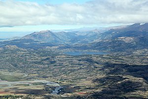 On top of the ridge we could see down to the town and over the whole
landscape towards the south. The valley of river Ibanez dominated the
foreground, behind it were hills, lakes, other rivers, patches of
forest and higher mountains in the background. The Carretera Austral
road crossed through from north to south-west with a couple of tiny
side roads starting from it. With the shadows of clouds over the land
the scenery looked almost like a painting. We sat down and watched it for a
while before continuing further on the trail.
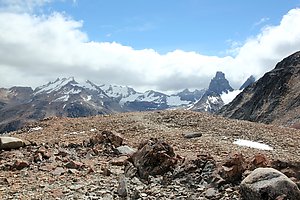 The trail went up on a shoulder of a mountain at about 1600 km of
altitude, the highest point of the hike. On our right we could see the
sharp peaks of the Cerro Castillo, partly hidden behind clouds. The
wind was blowing hard and we had to watch our steps when coming down
along the steep rocky slope on the other side. Then the trail went
again inside the forest where it was easier to walk, but still quite a
way until the campsite. Distance marked on the map was 1,4 km, which
was apparently just the straight line between the two coordinates and
had nothing to do with the actual walking distance on the path. On the
way, we met Simon, Jose and Clara, three Chileans from Santiago, and
walked together with them the last kilometers. Then it was time to set
up the tent, cook dinner and go to sleep as usual.
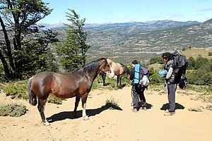 At the campsite there were a few more hikers going to different
directions. We headed down towards Villa Cerro Castillo, again
together with Simon, Jose and Clara. On the way we had a 1,5 hour
break when Simon set up his equipment and made a multi-channel
sound recording for his sound landscapes project. It was a sunny, hot
day and we were all quite tired when finally arriving to the town.
Next to the main road was a funny looking hamburger restaurant built
into two old buses. We ordered a burger each and a plate of french
fries to share. The service was slow but the burgers good and huge
— I was satisfied with one and Sandra with a half, the rest we
packed with us to eat later in the evening.
 After eating we bought fresh fruits and other food at the
minimarket on the opposite side of the street, said good bye to the
Chileans and started hitchhiking back to our bikes. There were no
buses any more, only a few cars and some competition from other
hitchhikers so we had to wait for some time. Finally we managed to
convince a pickup driver that there was enough space for us at the back
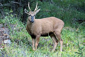
and got a ride. It was a cool ride through mountain landscape in the
evening light. And we were specially lucky because two huemules (a
Chilean species of deer) were next to the road and the family in the pickup was
also enthusiastic to see them. They stopped and we got good photos.
Back at the starting point of the trail our bikes were where we had left them behind a bush. We camped for a night, repacked our gear for cycling and continued further south along the Carretera Austral.
Seaside villages, huge leaves and roadworks on the Carretera Austral
Posted: 2015-01-31 22:48:00, Categories: Travel, Cycling, Hiking, Chile, 851 words (permalink)
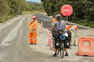 We spent 2,5 weeks in January cycling from Puerto Montt to
Coyhaique on the road number 7, better known as the Carretera
Austral. It is the main and only road leading south in this part of
Chile. Most of the villages and towns on the way are small so the
traffic wasn't heavy, and the road surface was in many parts still
gravel. However, as the only land route south it is becoming
increasingly important, and there is a big effort going on to make it
paved at least for the complete northern half until Coyhaique.
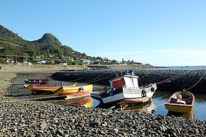 The first 60 km from Puerto Montt the road followed the seaside, a
relatively narrow passage between the island of Chiloe and the
mainland. The coast was lined with small fishing villages which looked
pretty in the late afternoon and evening sun. We camped on a small
grass field facing the sea and could see the sun setting behind
Chiloe.
 The next day we left the sea for a while and hit the first section of
roadworks: 20 km of bad gravel, dust, trucks and other machines
preparing the road for pavement, which unfortunately wasn't ready
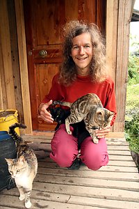
yet. The day was saved by a very nice guesthouse where we stayed with
eleven cats, other animals including dogs, ducks and goats, and a nice
family taking care of all of them and us as guests of course. We even
got homemade bread and duck eggs to complement our dinner which we
cooked ourselves in the kitchen.
 From Hornopiren there was a 5 hour passage by two ferries until Caleta
Gonzalo, where we entered the Pumalin Nature Park. It is private land
but maintained in a similar way than national parks, with marked
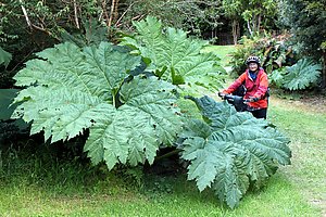
hiking trails, campsites and information services. The park was full
with lush vegetation, in particular large ferns and huge wild rhubarb
leaves (nalca in spanish), some of them more than two meters across.
It was clearly a region with lots of rain and we also had our share,
but luckily also a few sunny moments between the clouds. The campsites
were beautifully arranged and the same aesthetic appearance was
carried out throughout the park, including every sign and information
board. Unlike national parks, there were no entrance fees to access
the trails, and the campsites were very modestly priced at 2500 CLP
(about 3,5) per person.
 From Pumalin we came to Chaiten, where we stayed one night in a
guesthouse and refilled our food reserves in a supermarket. After
Chaiten the road was paved, relatively flat and we even had a good
tailwind for the next 40 km so it was easy cycling for a while. Then
it was gravel again, but a fairly pleasant and smooth one this time.
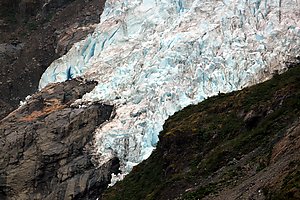
At Ventisquero Yelcho there was a free camping and a walking trail
leading to a glacier hanging down from the mountains.
 We started meeting more and more cyclists on the way, most of them
travelling south as we did. The majority were Chileans, but there were
many from other parts of the world as well. One of them, Alex from
Australia, joined us for a few days. Together we did a very nice
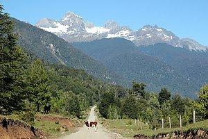
detour in a small quiet valley leading to lake Claro Solar. With the
mountains in the background and a couple of farms with cows on the
fields it looked a lot like German or Austrian Alps.
 We passed the town La Junta and about 40 km later stopped in another
called Puyuhuapi, where we stayed mostly inside because of the rain
and had a rest day. The Internet was good enough to
call our families, catch up a bit on what's happening in the world
(which we rarely do on the road) and search for information about the
areas coming up. In the night there were fireworks and a dance party
to celebrate the foundation of the town about 80 years ago.
 After Puyuhuapi we came to the Queulat National Park, where we saw
another glacier and had a relaxed evening with our own small campfire at
the park campground. The next day we cycled further and walked the
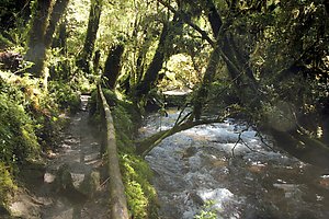
"Bosque encantada" (enchanted forest) trail through a
beautiful moss-covered old forest until a laguna up in the mountains.
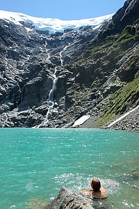 About 20 other people had also found their way there —
surprisingly many considering that the beginning of the trail was
poorly marked, and it wasn't one of the shortest nor easiest walks
either.
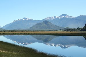
The last 180 km until Coyhaique the road was paved and not too
hilly, following river valleys between the mountains. It was sunny
again and one of the days was so hot that we had a long afternoon
break cooking in the shade and swimming in the Maniguales river.
 Traffic became heavier as we approached the city and the road was
narrow so it was probably one of the most dangerous sections of the
whole trip. Still, almost all the passing cars left us plenty of space
and we arrived safely to Coyhaique. That was a perfect place to have a
break, take a nice warm shower, get our clothes washed, communicate
with our WarmShowers hosts and prepare for the way further south.
Camping up in the mountains between border controls
Posted: 2015-01-17 05:47:00, Categories: Travel, Cycling, Hiking, Chile, Argentina, 592 words (permalink)
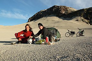 Our most spectacular campsite on this trip so far was near the Antonio
Samore mountain pass, right on the Argentinian-Chilean border. We set
up our tent on the plateau facing the Puyehue volcano with a panoramic
view of other volcanoes and mountains in every direction. The sunset
coloured the sky first orange and red, later violet, followed by a
clear full moon night.
In Argentina we cycled the classic "seven lakes" route from San Martin de Los Andes until Villa la Angostura. It was a pretty road, but the weather was cloudy and rainy so we didn't spend much time at the lakes. In Villa la Angostura we stayed in a hostel and celebrated New Year with other travellers, mostly Argentinians on their holidays. On New Year's day we already headed back towards Chile.
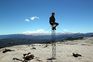 We camped one day at a river still on Argentinian side, and reached
the border at the top of the Antonio Samore pass on the second day.
The Argentinian customs and passport control had been already 20 km
before and the Chilean ones were 20 km further ahead. It seems to be
pretty common here that the border area is dozens of kilometers wide,
and it's not a problem to spend even several days between the control
points.
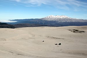 Only a few hundred meters after the pass on the right hand side was
a small jeep track leading up towards the nearby peaks. We followed
that and were soon like in a different world: sand everywhere, small
streams in deep canyons and a view towards all directions. We could
see the Puyuhue and Casablanca volcanoes, various other mountains and
also Puntiagido and Osorno volcanoes further away.
After about a kilometer we left most of our bags on the side of the track and continued further up with a lighter load. Then we left the bikes behind as well and climbed on top of the nearest peak. In the loose sand we got our shoes full of sand and small stones, but otherwise it was quite easy to climb. On the top we had a picnic and enjoyed the sunny afternoon.
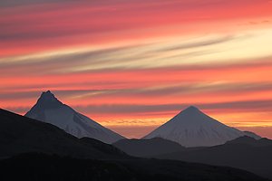 We descended on the north side and were directly on the border,
indicated by an old metal sign saying "Chile" on one side and
"Argentina" on the other. The track ended there but some footsteps
were going forwards. We followed them and climbed still the next,
slightly higher peak before coming back and picking up our stuff.
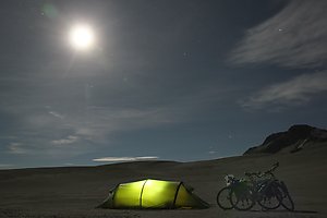 It was surprisingly windstill so we chose to set up the tent
directly on the open plateau at 1500 meters of altitude. It was a rare
place, with so much sand around and looking very dry, but still having
water available in several small streams. We cooked dinner and
prepared tea while admiring the sunset. Then we had a rest in the
tent, but came later out for a while to watch the moon and the stars
before going to bed. The temperature dropped below zero during the
night, but our sleeping bags were warm enough to sleep comfortably.
In the morning we had breakfast, packed our things, cycled back to the main road and further down to the valley towards Entre Lagos and Osorno. On the good paved road it was a fast ride through a quite strange landscape of dead trees. Later a park ranger explained us that it was a result of an eruption at one of the Puyuhue volcano side craters just a few years ago. The grey scenery lasted for about 10 kilometers, down in the valley everything was green again.
Hot springs and strawberries for Christmas
Posted: 2014-12-29 16:13:00, Categories: Travel, Cycling, Chile, Argentina, 930 words (permalink)
 This year we spent an alternative Christmas by camping and visiting
thermal baths along a small road crossing the Andes between Coñaripe,
Chile and San Martin de Los Andes, Argentina. In the morning of
Christmas eve we were the last time within the reach of mobile
networks and sent some "Merry Christmas" messages to our family and
friends, before being unreachable for several days.
 On December 23rd we cycled from Coñaripe on the shore of Lake
Calafquén further south-east to Liquiñe, the last village
before the climb up to the Carririñe mountain pass and the
Chilean-Argentinian border. There were several thermal baths in the
village and nearby. We followed the suggestion of the tourist info and
chose a modest one called Termas Trafipan where it was also possible
to camp. It had one bigger pool with warm water, perhaps around 35
degrees, and a separate building with small private rooms, each
containing a bath tub. Nothing fancy, but a good place to wash out the
dust of the road.
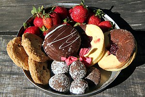
Being used to Europe it was a little funny to have Christmas in the summer, in the middle of strawberry and raspberry season. The shops in Liquiñe didn't have a very large selection of fruits, but we did find strawberries in one of them. Knowing that it would be the last chance of shopping before over 100 km of slow mountain roads, we also bought some apples and bananas before heading forwards. A sufficient stock of rice, pasta and other dry foods we had already acquired a couple of days earlier.
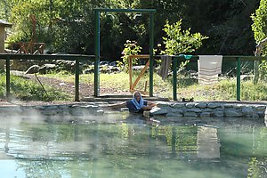 After 10 km of up and downhills we came to Termas Hipolito Muñoz.
After a short look around it was clear that we'd stop there for the
rest of the Christmas eve. It had an idyllic setting in the river
valley, plenty of trees to provide shade from the afternoon sun and
good, clean sanitary facilities. For bathing, there was one warm pool
and another hot one with clearly over 40 degrees, plus showers and the
river providing for cold water. All of them were outside, open day and
night so it was possible to take a bath under the stars too. It was
peaceful and quiet, simply a wonderful place. There was
also a small rustic steam sauna, which looked interesting but the
smell of sulfur was so strong that we came out after a few seconds.
There would have been cabins to rent but the weather was constantly sunny so we didn't see any need for one and set up our tent. We were the only ones camping, in addition to us there were just one family in a cabin and a couple of day guests who didn't stay overnight. We spent a relaxed afternoon in and outside the pools before preparing dinner. It consisted of spaghetti with tomato sauce, followed by tea, strawberries and a selection of cookies for dessert. We invited a Chilean couple to share the cookies with us and they brought us orange juice and avocadoes, which we had for breakfast next morning. After the sunset we had a night bath before going to sleep.
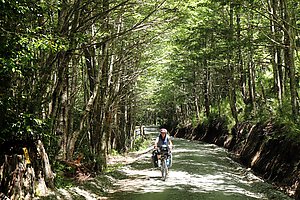 We thought of staying a second day but decided to continue towards
the border on the following day. The road became smaller and smaller
but at the same time easier to cycle, because the surface was smoother
than on most gravel roads which are covered with a layer of small
stones. Traffic was non-existant, so we also didn't have any dust to
worry about. In the afternoon we reached the Chilean border post, which
was manned but closed. The suprised border guards had a short
negotiation between them about whether we could stay at the border,
but decided to send us away. We pedaled about a kilometer back, camped
in the forest out of sight of the guards and came back the next
morning.
This time we had better luck, there had been a change of shift and the new guards were ready to open the border. We were apparently the first ones wanting to cross, as it took a bit of time before they started their computer, examined our documents, took a photo of us with a mobile phone (!), and adjusted the right date in the stamp after first stamping our passports with completely wrong date. All of that was carried out in a very friendly manner and then we were off towards Argentina.
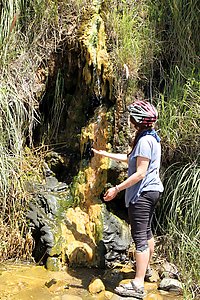 The last three kilometers before the highest point of the pass were
very steep and we had to push our bikes at least half of the way.
After that it was almost as steep downhill on the Argentinian side,
descending to the Lanin National Park. There we had one more visit to
thermal pools, this time free ones next to a trail in the park.
However, those pools had more murky water and were in general less
attractive so we didn't spend too much time there.
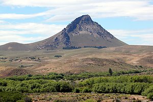 It took us two days to cycle through the park. It had less trails and
facilities than the parks we had been visiting in Chile, but a similar
mix of forest, lakes, rivers and mountains. When moving more east the
terrain became slowly more and more dry, opening a whole new type of
scenery in front of us. Eventually we also reached the Argentinian
border control post, which was more than 50 km away from the actual
border. Again stamps in the passports and we were officially in a new
country. One more day of cycling brought us to San Martin de Los
Andes, the biggest town of the region with about 24000 inhabitants.
Volcanic scenery in Malalcahuello and Conguillio
Posted: 2014-12-29 16:06:00, Categories: Travel, Cycling, Hiking, Chile, 823 words (permalink)
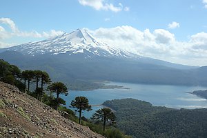 We spent 1,5 weeks exploring the Malalcahuello National Reserve and
the Conguillio National Park, both on foot and by bicycle. Both parks
were dominated by volcanoes and their past activity, including several
eruptions during the last 100 years. The contrast between almost black
volcanic sand and lush green forests was dramatic. There were a lot of
magnificent hundreds of years old trees, with thick layers of
lichen growing on the trunks and hanging from the branches.
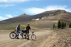 We started by cycling from Victoria to Curacautin and further to
Malalcahuello where we stayed with Claudia from CouchSurfing. She had
a beautiful house a few km outside the village, so deep in a valley
between the mountains that we didn't even have mobile phone
reception there. It was a good place for relaxing and an excellent
base for tours in the region.
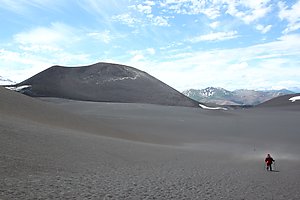 On one day we cycled up along the road leading to a ski center at the
Lonquimay volcano, the highest peak of the area. There was still quite
a bit of snow covering the higher parts of the volcano, but not enough
for skiing so it was off-season and quiet. From the ski center started
a still smaller road, marked as being for 4x4 vehicles only but it was
also suitable for bicycles.
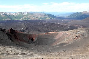 The road led us across dark volcanic sand to a sign which marked
the start of a walking trail to Crater Navidad, the crater of the last
eruption of the volcano on Christmas day 1988. After a 1,5 hour walk
through the dusty sand field and a slope of loose stones we stood at
the edge of the crater, at 1891 meters of altitude. It was almost 1000
meters lower than the main volcano but had a panoramic view over the
lava flow and the surrounding area. The rocks at the crater had
many different colours, a lot of varioud shades of red, some white,
brown and yellow in addition to the dominatic nearly black rocks.
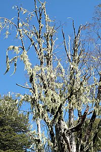 On another day we walked the Piedra Santa trail which started down in
the village and went through a forest on top of a hill. There were a
lot of old trees with lichen hanging from every small
branch, creating a quite special atmosphere. In higher altitudes,
other tree types gave way to the Araucarias, our favourite tree
because of their beautiful shapes against the blue sky. Because of the
approaching holidays we called them the Christmas trees of Chile. We
also saw a pair of condors cruising in the air. Otherwise there were
surprisinly few birds to see or hear, we thought that in such an old
forest we'd be hearing birds singing almost all the time.
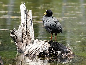 From Malalcahuello we returned to Curacautin and continued south
through the Conguillio National Park. It had also black volcanic
scenery like the Malalcahuello Reserve, but more lakes and also
non-volcanic peaks of more than 2000 meters. The main road through the park was a narrow
gravel and earth road, allowed for all kinds of vehicles but some
parts would have been fairly difficult to manage with a normal car. No
wonder that the most common vehicles in the Chilean countryside are
4-wheel-drive pickups, jeeps and SUVs. There it at least makes sense
to have one, unlike in most places in Europe and North America where
even minor roads are so good that a normal car is not only more fuel
efficient but also better to drive.
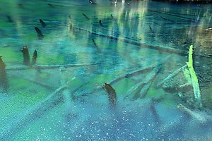 The highlights of Conguillio were the lakes, each of which had a
different character. Laguna Captrén had sunken trees sticking
out of the water and several bays with more bird life than we saw in
other areas of the park. The Conguillio lake was the biggest lake with
a panoramic view of the mountain range behind it, and an interesting
mix of volcanic rocks and plants on the shore. But perhaps the most
beautiful was the tiny Laguna Arco Iris, which was surrounded from one
side by a lava field and from the other side by forest, and had
wonderful colours in the water when looking down from the shore.
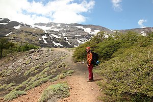 We also did a one day hike on the Sierra Nevada trail, which went up
from the Conguillio lake to the non-volcanic peaks. We didn't climb
until the top but above treeline and had very varying scenery on the
way. From a distance the mountains looked a lot like the Alps in
Europe, but both the trees and other vegetation were quite
different.
Overall, we were surprised how few people we met on the trails. They were easy to walk and well marked, but it seemed that most of the visitors just drove through the park by car, perhaps stopping at a couple of sightseeing spots. We think that by doing so we'd be missing a lot — even by going slowly on a bicycle it's not possible to reach areas away from the roads and see the nature in the same detail than on the walking trails.

Copyright Arto Teräs <ajt@iki.fi>, licensed under the Creative Commons Attribution-Share Alike 3.0 Unported License. (Unless otherwise mentioned in individual photos or other content.)